CarHab is a national cartographic modeling program for natural and semi-natural habitats in France.
Initiated as part of the national biodiversity strategy 2011-2020, this program led by the Ministry in charge of ecology aims to meet the challenges of biodiversity conservation, land use planning and sustainable management of natural resources. Its objective is to carry out by 2026 a national mapping of natural and semi-natural terrestrial habitats of mainland France and the French overseas territories, at a scale of 1: 25,000th.
The results should provide information on the location of habitats and will support national and territorial public policies related to land use planning and knowledge of biodiversity. They will also make it possible to better respond to community commitments linked to the Habitat-Fauna-Flora Directive, in particular for the distribution of habitats of community interest.
Three objects of study are considered in the CarHab program:
• Biotopes: hey consist of ecologically homogeneous surfaces (identical edaphic and climatic conditions within which constant ecosystem potentialities are expressed (identical biocoenoses, syntaxons, functionalities).
They constitute the surface support of vegetation series (temporal successions of vegetation stages). The definition of biotopes is based on the combination of 8 parameters: coastal character, vegetation stage, ombroclimate, continental character, bioclimatic variant, soil moisture, soil acidity and duration of snow cover.
Modeled map of biotopes in the Cher department

• Vegetation physiognomies: physiognomies correspond to the main stages of development of plant communities during the natural time dynamics of vegetation.
The modeled maps contain 26 physiognomy classes.
Example of physiognomy of vegetation: Mown grassland.
Modeled map of the vegetation physiognomy in the Cher department

• CarHab Habitats: they come from the combination of information from the modeling of biotopes and that of the physiognomy of vegetation; each polygon resulting from this crossing contains information relating to the biotope (combination of the 8 edaphic and climatic parameters) and on the physiognomy of corresponding vegetation (stage in the dynamics of vegetation development).
Mown grassland in the interior of the montane level under a hyperhumid umbroclimate in a sub-oceanic situation, without bioclimatic variants, on basic, humid soil with a circulating water table marked by no to short snow cover (0-4 months)
Modeled map of natural and semi-natural habitats in the Cher department using a simplified legend

The habitats modelled by the CarHab programme are matched with the European EUNIS habitat typology and the Habitats of Community Interest.
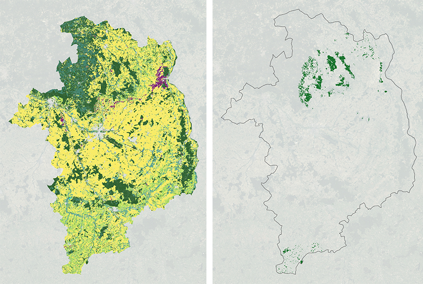
Map of EUNIS habitats predicted in the Cher (left), map of Habitats of Community Interest "9120 Atlantic acidophilous beech forests with Ilex and sometimes Taxus undergrowth" predicted in the Cher (right).
The biotope and vegetation physiognomy maps for each department are produced by supervised modelling using a Random Forest algorithm. The National Botanical Conservatories provide the training data for the model from existing data on their territory. For the vegetation physiognomy, the modelling from satellite images (Sentinel-2) is completed by information layers from the BD Forêt® and the BD TOPO® of the IGN. For biotopes, the modelling is based on geographical information layers of environmental variables (topography, climatic data, geology, pedology, sunshine, etc.). A field survey phase is used to refine the model.
The wide range of skills required for the implementation of the CarHab program (naturalists, IT, biostatistics, data administration, dissemination and promotion) requires the involvement of a large network of actors and structures located throughout France and acting in concert to achieve the objectives defined by the ministry in charge of ecology.
The following structures are the main actors of the programme:
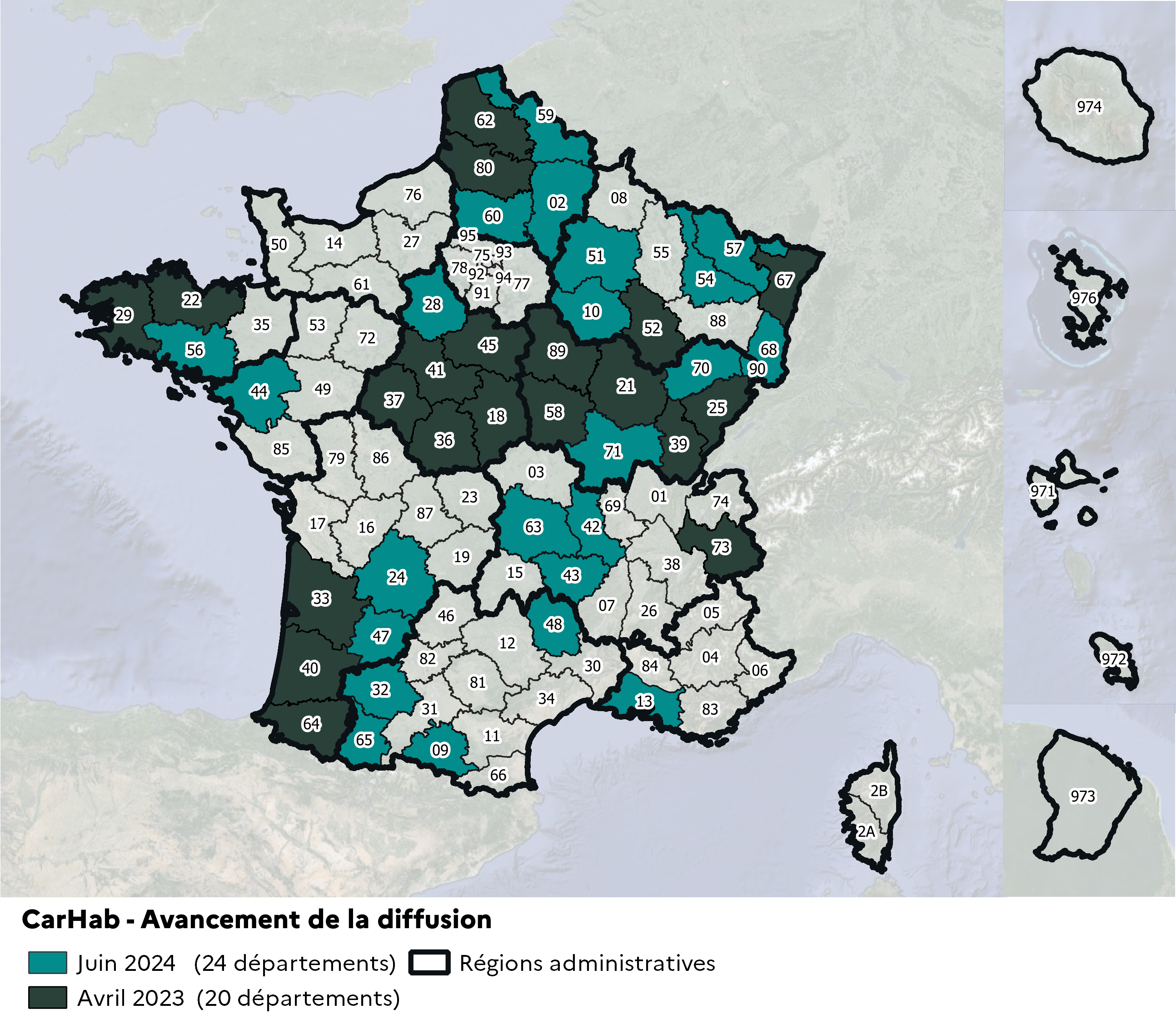
Map of the 44 departments for which CarHab data is available
 Download the national CarHab notice describing the data production methodology:
CarHab notice
In each departmental zip file:
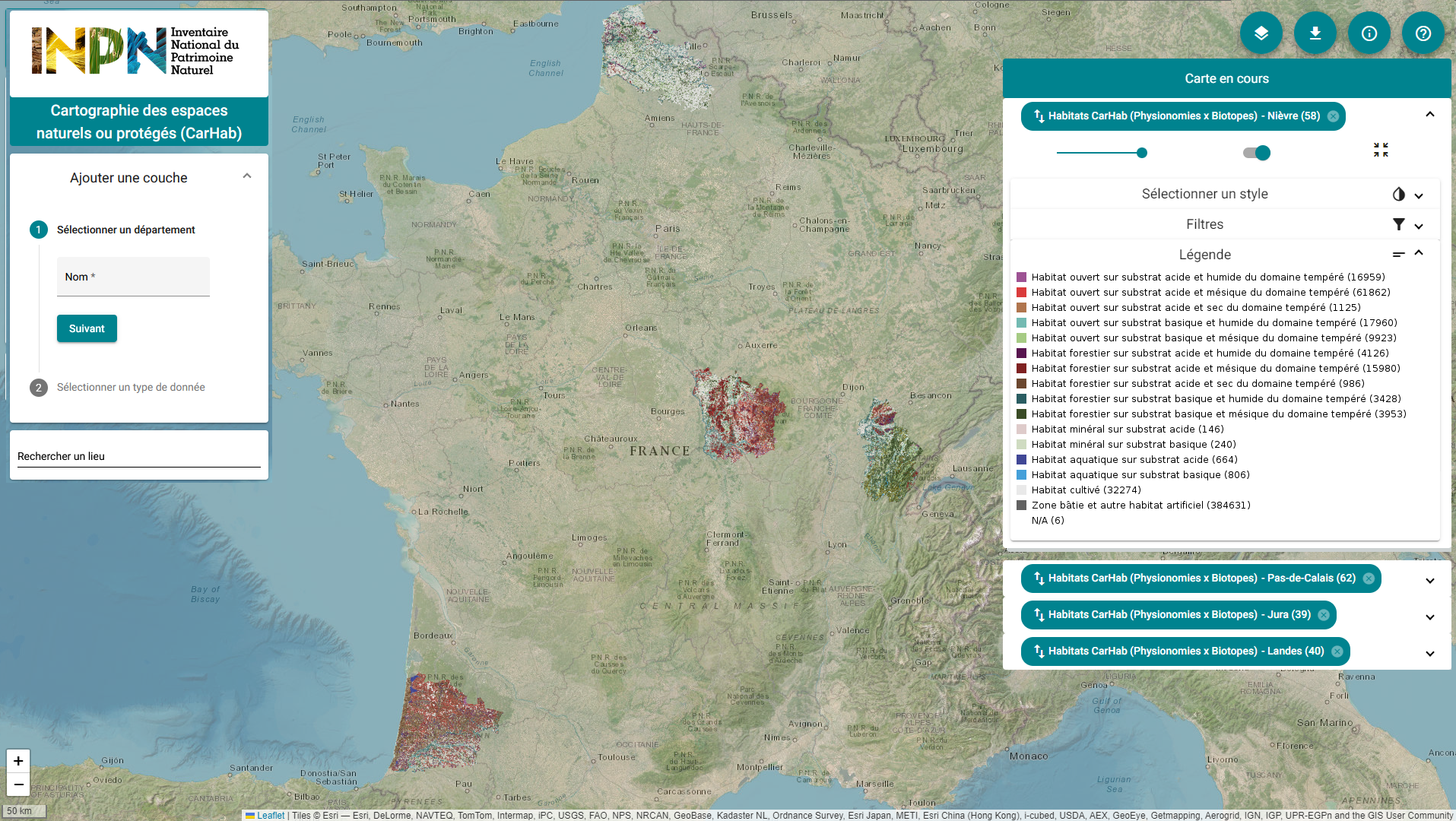
An online map viewer allows you to see the data produced by Carhab, to filter the data displayed, and to download the data department by department.
 French Version